More media 11
Description
Messing around on Google maps. Have taken phone screenshots so you all can search for the locations yourselves.
First up, Site C6 at Eglin AFB - apparently the location of orbital monitoring. If you search for "Site C6" on this subreddit you should find threads about what's inside. That's one freaky building, with some massive air pumps that don't seem to connect to anything. Also note the field to the south of it, which seems to have little pipes coming up out of it - almost certainly an underground facility, which is neat as hell.
Then is the Lockheed Range at Helendale - with an aerial shot, and a photo from Google showing the deployed facility and an aerodynamic model. Also super cool, this would be an incredible site tour.
Then is the Space Force Command Centre, formerly Norad, which is a tunnel going straight into Cheyenne Mountain. You can see it in the aerial shot as the road that runs into what looks like a shed. There are loads of photos from ground level of the entrance on Google. Also pictured is the Subway Sandwich Shop just outside the entrance. Imagine having to get security clearance to work as a sandwich artist!
Then it's onto Nevada, and the awesome "clam-shell" hangars at Are 6 (South of Groom Lake, East of the Device Assembly Facility).
Photo 9 is three "Janet" flights at Groom Lake. Janet is the secret airline that flies staff to Groom Lake and to Tenopah. You can just see them hanging out at Las Vegas airport apparently, and you can track them in the air at commuter time on FlightRadar24 - you can follow them all the way to Tenopah, but the ones headed to Groom Lake switch their transponders off once they enter classified airspace. This is a great, short video about them:
https://youtu.be/pWNGAUvSyOc
Photo 10 is Edwards AFB in California, North of Los Angeles, and what looks to me like a drone next to the runway, with what I think is a training jet alongside. Just cool to see, I think.
Photo 11 is Edwards again, and a B1 in what looks like a staging area or just a display area (there's loads of aircraft on display around Edwards if you go looking, most of them with their own markers on Google Maps!).
Hope you have fun scanning around - please share if you find anything interesting! I just think it's neat that we can just look at aerial photos of all theae top secret facilities on our phones now. I could spend days trawling through these locations.
Comments 0
Sign in to join the discussion.
What do you think it is?
Sign in to vote. 0 votes.
👥 Other witnesses
🙋 I saw this tooSaw it too? Add your account — independent witnesses are the best evidence.
🔔 Alerts for sightings like this
🌤️ Sky conditions weather, moon, planets, satellites, aircraft & launches at that time
Source
u/lockedupsafe on r/UFOs
Citations
https://www.reddit.com/r/UFOs/comments/156vp8d/having_fun_ln_google_m…
Nearby sightings within 100 miles
 Weird Lights Moving in the SkySame place
 Possible Rocket?Same place
 UFO??Same place
 Huge lights last night in Mendocino County, CaliforniaSame place
 Sequoia National Park UAPSame place
 Illuminated fast moving object in Northern California skySame place
 Anyone have any idea what it was?Same place
 Has anyone seen something like this before? I’m sorry I’m not an artist but I tried to capture what I saw while doing yard work. The best way I can describe it is It was a metal egg cut in half…Same place
 Can someone tell me what this is?Same place
 Triplet UFO (digital thermal footage)Same place
 A Navy chief told a House task force a Tic Tac rose out of the Pacific beside USS Jackson in 2023. What does the sensor data actually show?Same place
 Strange Lights, South OC, California, 9/3/22Same place
Similar sightings described alike
 Drone like UFO's/UAP's on Google Earth. 23 cases so far...Argentina
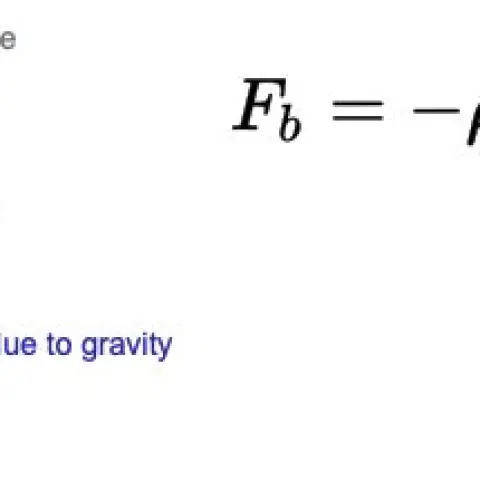 I've decided to open source my research into vacuum balloons and a potentially new approach to nano foams. This information is very interesting when compared to the UFO metal sphere analysis…
 Let’s Bury The Int Community In Contact - Write To Disclosure 3
 All this talk about technology transfer to the private sector and speculations about mysterious finds in Antarctica look pretty interesting now that I'm investigating the history of Antarctic…
 The Golden-Haired, Bare-Skinned Alien of 1897Springfield
 Mage, Brazil UFO Mega postMagé · 2020
 IMMACULATE CONSTELLATION searches back to 2004 - Google Trends deleting data?2004
 MH370 Airliner videos part III: The rabbit hole goes deeper than we thought2014
No comments yet. Start the conversation.